
Directions
Where is Vacaville?
Centrally located, Vacaville’s gateways include the Sacramento, San Francisco, Oakland and Nut Tree airports. Vacaville travel has never been easier, with inter-city bus, taxi, and area transit services.
Arriving by Air
Getting to Vacaville is simple. Centrally located off the I-80 corridor, Vacaville is:
- 37 miles SW of the Sacramento Airport
- 57 miles NE from the Oakland Airport
- 65 miles NE from the San Francisco Airport
- Small engine pilots can also check out the Nut Tree Airport.
Transportation Options
707.449.6000
City Coach is Vacaville’s primary public transit system, operating eight bus lines servicing all of Vacaville, offering services to the Vacaville Premium Outlets, Brenden Theatres, Three Oaks Community Center, and the Ulatis Cultural Center.
Operates Mon – Sat, 6:35 a.m. until 6:33 p.m.
800.53.KMUTE (535.6883)
SolanoLinks offers links to Solano County from Napa, San Francisco, and Sacramento as well as information on local airport shuttles.
Fairfield/Suisun Transit (FTS)
707.422.BUSS (422.2877)
Bus services from Fairfield, Dixon, Davis, Sacramento, the Pleasant Hill BART station.
707-648-4666
Bus services from Fairfield, Vallejo, and the El Cerrito del Norte BART station. Baylink ferries operate daily to San Francisco.
1040 Mason Street
707.447.5989
Extensive bus service network throughout California and the US.
Car Rentals
Avis Car Rentals
1307 Callen Street
Vacaville 707.452.1119 Hertz Car Rentals
630 Orange Drive
Vacaville
707.454.3855
Enterprise Rent-A-Car
630 Orange Drive
Vacaville
707.452.0300
Car Services
Ambassador Limousine
607 Elmira Road, Suite 309, Vacaville
800.767.LIMO
Yellow Cab Company of Vacaville
707.446.1144 or 707.449.TAXI
Train Services
877.700.7275
The Bay Area’s mass transit system travels to over 40 destinations in the Bay Area.
800.USA.RAIL
Multiple departures throughout the Capitol Corridor from Auburn to San Jose.
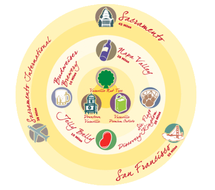
Drive times to Vacaville
- San Jose – 1hr 30min
- Napa – 31 min
- Sacramento (downtown) – 45 min
- San Francisco – 1 hour
- Stockton – 1 hr 10min
- Redding – 2 hrs 30 min
- Oakland – 50 min
- Sonoma – 40 min
- Los Angeles – 6hrs 15min
- Monterey/Carmel – 2hrs 35min
- Reno – 2hrs 45min
- Lake Tahoe – 2hrs 45min
CHECK OUT OUR VACAVILLE CA MAP FOR TRAVEL INFORMATION
Easily accessible by airplane, train, car, and public transportation, Vacaville boasts a central location convenient to several big cities such as San Francisco Oakland, and Sacramento. Vacaville’s proximity to some of California’s most popular attractions makes it an ideal base of operations for any trip to north-central California. We’re also a short drive to the acclaimed Napa and Sonoma wine regions and the amazing Sierra mountain range resort of Lake Tahoe. Get more information on our Vacaville, CA map below.
FEATURING A DYNAMIC ARRAY OF CENTRAL VALLEY VACATION OPTIONS
Vacaville is one of the state’s most unique and dynamic places to visit, shop, stay, and play. A short drive from San Francisco and Sacramento, this scenic locale offers excellent performing arts venues, restaurants, shopping, and outdoor recreation. Learn more today.